
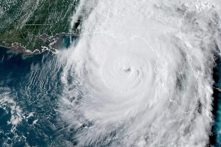
This GOES-16 GeoColor satellite image taken at 5:46 p.m. ET and provided by National Oceanic and Atmospheric Administration (NOAA) Shows a 350 mile wide Hurricane Helene in the Gulf of Mexico moving toward Florida, on Thursday. (NOAA/The Associated Press)Why Hurricane Helene was so destructive – Search (bing.com)
Hurricane Helene was destructive due to several factors12:
It was large, about 350 miles wide.
It was strong, with winds reaching 140 mph when it made landfall.It brought heavy rains.
It caused widespread storm surge.
It uprooted trees, splintered homes, and strained dams.1How Helene became the near-perfect storm to bring widespread …abcnews.go.com2Helene’s destructive trail across southeastern U.S. leaves at … – PBSpbs.org
Parts of the Southeast, including North Carolina, had been dealing with rain before Helene arrived. Together, the storms dumped 40 trillion gallons of water — the equivalent of Lake Tahoe — on the region in over a week, the Associated Press reported.
Typically, hurricanes weaken and winds die down as they move from the warm ocean to dry land. While Helene did devolve into a tropical storm as it moved inland, the warm, sodden ground from previous rains could have helped propel the storm more forcefully than usual, Dev Niyogi, a University of Texas at Austin earth and planetary sciences professor, told The New York Times.
“This has been an unprecedented storm that has hit western North Carolina,” North Carolina Gov. Roy Cooper said. “It’s requiring an unprecedented response.”
Swollen rivers overflowed, landslides cut off roads, and flash floods swept people away as they tried to find safety. The last time Asheville saw anything like this disaster was in 1916 during the collision of two tropical storms, which killed 80 people, according to The Washington Post. The affected states are trying to coordinate disaster relief along with recovery and rescue. Hundreds of people are still missing or unable to contact loved ones.
Some mountainous areas are relying on helicopters to bring necessary supplies. Reaching rural areas has also been a struggle.”We know there’s areas we haven’t gotten to yet,” FEMA Administrator Deanne Criswell told CNN, “and so we’ll continue to get that information of the places that still need critical equipment, critical food and water.”
Before and after satellite photos show Hurricane Helene’s destruction of the Florida coast (msn.com) Hurricane Helene poured a devastating deluge on the southeastern U.S. this past week, killing at least 130 people by Tuesday, leaving hundreds missing, causing record flooding and storm surges and cutting power to millions of homes and businesses.
Here’s a look at just how bad it was — and a few reasons why.
U.S. National Oceanic and Atmospheric Administration (NOAA), with violent winds extending up to 560 kilometres from its centre. It was also travelling twice as fast as a typical Gulf of Mexico storm striking the coast.
The storm made landfall in Perry, Fla, on Thursday night as a Category 4 hurricane, with winds reaching 225 km/h, according to NOAA, which said it was one of the most powerful ever to strike the U.S. On the Florida coast, it caused storm surges of up to 4.6 metres.
Meteorologist Ryan Maue and Ed Clark, head of NOAA’s National Water Center, independently calculated that 151 trillion litres of water poured down on the southeastern U.S. over four days. That’s enough to fill and overflow Lake Athabasca, Canada’s tenth largest lake, or cover the entire surfaces of both Nova Scotia and New Brunswick together more than a metre deep.
 Hurricane Helene’s death toll; widespread damage and power outages persist.
The deluge caused record flooding in at least seven locations in North Carolina and Tennessee, the BBC reported. In Buncombe County, N.C., where the town of Asheville suffered major damage, Ryan Cole, a local emergency services assistant director, described its impact as “biblical” devastation. What made Helene so bad?
Many places hit by Helene, such as Asheville, N.C., had already been pounded by rain from other two or three other storms before the remnants of the hurricane arrived, including one that fell just short of named status along North Carolina’s coast, said state climatologist Kathie Dello.
“Torrential rainfall from the remnants of Hurricane Helene capped off three days of extreme, unrelenting precipitation,” said the North Carolina State Climate Office in a blog post Monday.
That meant streamflows were already at daily record highs and soils on local mountain slopes were already saturated by the time the remnants of Helene brought more heavy rain.
As Helene passed through, it could have mopped up some of the evaporating water as additional energy. That’s a phenomenon known as the “brown-ocean effect” since it resembles, on a smaller scale, the normal building of storms from ocean heat and evaporation.
Marshall Shepherd, director of the University of Georgia’s atmospheric sciences program, told The New York Times that could have been a factor, and he and his colleagues are planning to study how much the effect could have contributed to Helene’s force.
Helene was so fast and powerful that it moved far inland. Some of the areas most devastated by the storm were in the Appalachian Mountains of North Carolina, which saw “catastrophic flooding and unimaginable damage,” the state’s climate office said.
As storm clouds moved into the mountains, they were forced up and over. That “tends to squeeze out more rainfall,” Doug Outlaw, a National Weather Service meteorologist told NBC News.
All that rainfall then rushes downhill.
Hurricanes are fuelled by warm ocean waters, and the heat has been “off the charts” in the Gulf, where Helene picked up steam after forming in the Caribbean Sea last Monday, reported Judson Jones, a meteorologist for The New York Times.
The storm strengthened very quickly — a phenomenon called rapid intensification. Helene had become a Category 1 hurricane by Thursday morning, and had intensified to Category 4 within 12 hours.
The ocean warming caused by climate change has generally led to hurricanes producing more rainfall, moving farther inland and undergoing rapid intensification more often.
In the case of Helene, climate change caused it to drop 50 per cent more rainfall in some parts of Georgia and the Carolinas, and made those record rainfalls up to 20 times more likely, reported researchers at Lawrence Berkeley National Laboratory in a rapid climate attribution study released Monday. That study is based on methods used for a similar study on Hurricane Harvey, but has not yet been peer reviewed.
Why was Helene so bad?
In the days before Helene made landfall, it drew a lot of energy from the very warm waters of the Gulf of Mexico, strengthening quickly from a Category 1 to a powerful Category 4 hurricane. High sea surface temperatures meant there was a lot of moisture in the atmosphere capable of producing a vast amount of rain and this moisture was carried deep inland by the storm.
Most very powerful hurricanes do strengthen rapidly but what was unusual about Helene was the sheer scale of the storm’s rain clouds and wind field coverage.Despite the storm making landfall on Florida’s Big Bend, even cities such as Miami, many hundreds of miles away, experienced wind gusts of more than 70mph (110km/h), due to Helene’s vast size.
It also meant the extreme rainfall took a long time to pass over any location in Helene’s path.
Why was North Carolina so badly hit?
More than six months’ worth of rain landed in parts of North Carolina as Helene passed through.The mountainous western part of the state suffered huge impacts from the storm due to its topography, with homes and bridges washed away, villages flattened and the tourist city of Asheville cut off.
Mountainous terrain typically receives heavier rain than lowland areas.
Tropical systems also tend to bring especially heavy rain so it is not surprising that river levels rose so rapidly and flash flooding was so extreme, cutting off vulnerable communities in the state. Media caption, Sarah Keith-Lucas describes Helene’s destructive path across the south-eastern United States.
How bad was the flooding?
Helene brought historic flooding and a storm surge of more than 15 feet (4.5m) as it barrelled across the south east of the US.Record flood crests were measured in at least seven locations in North Carolina and Tennessee. In parts of western North Carolina, records that had stood since the “Great Flood” of July 1916 were smashed.
The states in the storm’s path had already had a lot of rain in the days ahead of Helene’s arrival, so the ground was already saturated. This meant flooding was more likely because the ground could not absorb any more water.The destruction across the south-eastern states was also down to a phenomenon known as the “brown ocean effect”.
This is when a storm continues to draw some energy as it passes over wet ground, so it does not fizzle out as fast as a storm that crosses dry terrain.
Could climate change have made Helene worse?
Initial analysis of the storm already suggests that human induced climate change played a significant role in the amount of rainfall dumped by Helene.
One rapid attribution study, external claims that climate change caused over 50% more rainfall during Hurricane Helene in some parts of Georgia and the Carolinas.
Another study, external found that cyclones similar to Hurricane Helene are up to 20% wetter over the south-east of the US and up to 7% windier in Florida’s Gulf today compared to the past.
It is well understood that a warming climate means a wetter world. That is because a warmer atmosphere holds more moisture, which produces more intense rainfall.
We could see the impacts of tropical cyclones reaching further inland in a warming worldInitial analysis of the storm already suggests that human induced climate change played a significant role in the amount of rainfall dumped by Helene.
August 23,1992 Hurricane Andrew documentary – Search (bing.com)
August 25,2005 Hurricane Katrina documentary – Search (bing.com)
US20030085296A1 – Hurricane and tornado control device – Google Patents
Can we expect more storms like Helene this season?
The Atlantic hurricane season continues until the end of November and it is not unusual for storms to form even later. So far this year, we have seen ominous signs of strong storms developing much earlier in the season due to the very warm waters of the Caribbean. Back in July, Beryl became the earliest category five Atlantic hurricane in records going back around 100 years.
There was a lull in Atlantic hurricanes forming mid-season due to an unusual pattern in the West African monsoon, which prevented storms brewing in the area where they usually thrive. The waters of the Gulf of Mexico and Caribbean are currently above average temperature, meaning there is more potential for powerful storms to develop through the rest of the autumn.
What we covered here
• Helene makes historic landfall: Hurricane Helene made landfall in Florida as a Category 4 storm and is now a Category 1. It is the strongest hurricane on record to slam into Florida’s Big Bend. You can track Helene’s path with CNN’s storm tracker.
• A sprawling storm: Helene is one of the largest storms in the Gulf of Mexico in the last century, with a wind field that could span roughly the distance between Indianapolis and Washington, DC. Watches and warnings are in place for 60 million people in 12 states.
• “Unsurvivable” storm surge: Storm surge — how high the water rises above normal levels — could climb to 20 feet along Florida’s Big Bend. The National Weather Service is warning of “unsurvivable” storm surge in Apalachee Bay.
• Widespread impacts: There have been at least three storm-related deaths. Catastrophic wind damage from the storm could cause power outages that will “likely last days, if not weeks.” Helene has also prompted school and business closures, as well as flight cancellations.
• In the path of Hurricane Helene? Bookmark CNN ‘s lite site for fast connectivity. Sigue nuestra cobertura en vivo del huracán en español.
Six states are under states of emergency as Hurricane Helene batters the Southeast after slamming into Florida’s Big Bend. The storm made landfall as a Category 4 hurricane and although it has now weakened to Category 1, torrential rains and ferocious winds have caused widespread damage to homes and infrastructure.
Storm watches and warnings are also in place for 60 million people in 12 states.
These states have declared emergencies:
- Florida: Gov. Ron Desantis said 61 of Florida’s 67 counties are currently under a state of emergency.
- Georgia: All 159 counties were placed under state of emergency, enabling emergency management teams to make necessary arrangements and position needed resources ahead of the storm’s arrival.
- North Carolina: Gov. Roy Cooper warned “Helene is an unusually dangerous storm that threatens to bring heavy rain and potentially catastrophic flooding” on Thursday night though Friday for central and western parts of of the state.
- South Carolina: Gov. Henry McMaster said: “We will likely avoid the brunt of this storm, but it is still expected to bring flooding, high winds, and isolated tornadoes.”
- Alabama: President Joe Biden approved an emergency declaration for the state and ordered federal assistance to those affected by Helene.
- Virginia: Gov. Glenn Youngkin said the state “cannot ignore the fact that we have had significant flooding events arise from pre-cursory rain events and outer bands from tropical systems that drop locally heavy rainfall leading to flooding, especially in our southwestern region.”
- Ohio: Gov. Mike DeWine has declared a state of emergency in four Ohio counties after severe weather caused high winds, flooding, and power outages. A state of emergency has been declared for Lawrence, Jackson, Pike, and Scioto counties after severe weather on Sept. 27 caused by the remnants of Hurricane Helene.
- West Virginia – A news release reports Gov. Jim Justice (R-W.Va.) declared a State of Emergency Tuesday afternoon, following significant damage caused by the remnants of Hurricane Helene. Tuesday’s proclamation came just hours after Gov. Justice appeared to downplay the damage, saying “In all fairness, we have had many situations as far as weather in West Virginia that were much more damaging and everything to this event in West Virginia. You know what it did in North Carolina.”
- In Tuesday’s proclamation, Justice said the following: We’re still learning about reports of serious damage throughout Mercer County. W.V., and the estimates are adding up quickly. I’m told there’s a sizable portion of the county still without power, and there were so many downed trees that it’s been difficult to get the full scope of what’s happened. This State of Emergency will allow us to speed up the response on the ground and potentially receive federal assistance as we push forward with recovery efforts…This storm is one that we’ll remember in Appalachia for a long, long time. We’ve seen some really troubling images from our neighboring states, but there’s no question that Helene has left its mark here at home, as well. We’ll continue to pull the rope together and take care of each other, because that’s what we do in West Virginia.
Helene Landfall Pressure – Search (bing.com)
The estimated minimum central pressure based on data from the Air Force Hurricane Hunters is 951 mb (28.09 inches).
Post-Tropical Cyclone Helene Public Advisory – National Hurricane …
www.nhc.noaa.gov/text/refresh/MIATCPAT4+shtml/252107.shtml
******
7:15 AM | *The 50th anniversary of Hurricane Camille* — Arcfield Weather
Devastation far inland with catastrophic flooding in Virginia…
Camille weakened to a tropical depression as it passed through northern Mississippi and into western Tennessee. It then took a turn to the northeast through central Kentucky and then eastward through extreme southern West Virginia and southern Virginia.
By the 19th of August, atmospheric conditions were coming together for extreme rainfall and local geographic features were enhancing chances for catastrophic flooding in the eastern slopes of the Blue Ridge Mountains – but few were prepared for what was about to take place.
Specifically, the remains of Camille were moving into an area where there was tropical air in place along with an existing backdoor cold front at the surface and an intensifying jet streak aloft. In this part of Virginia, there is a narrow valley with steep ridges and an upsloping wind amplified rainfall amounts. The combination of this extremely unstable atmosphere and local geographic features was resulting in historic and deadly flooding conditions.
Hurricane Camille documentary premieres in Mississippi ahead of 50th anniversary of landfall (youtube.com) | Hurricane Camille documentary – Search (bing.com)
Normal ocean water temperature – Search (bing.com)
normal ocean water temperature – Search (bing.com)
Rainfall amounts were disastrous across the northern Gulf coast and in the eastern slopes of the Blue Ridge Mountains; credit NOAA
Rainfall amounts of more than 26 inches occurred in the mountain slopes between Charlottesville and Lynchburg, Virginia in a 12 hour period. Nelson County, Virginia recorded 27 inches of rain with reports that the rain was so heavy there were birds drowning in trees. [A post-storm “reanalysis” by NOAA suggests over 30 inches of rain fell in as little as eight hours in some spots].
Survivors recall a night between the 19th and 20th of August that was filled with thunderstorm after thunderstorm and lightning was so fierce “it was like daylight and the lightning didn’t flash, the sky just literally stayed lit”. A total of nearly 3800 landslides within Nelson County, Virginia alone were calculated using LiDAR scans and 123 of the 153 fatalities in the state during this storm took place in this particular county.
After Camille, the landscape had changed so much that topographical maps were obsolete. To this day, hillsides still remain bear with exposed rock where mudslides ravaged and stripped the forest away. The rainfall tripled the state of Virginia’s record and has not been broken since. (Credit to Jason Elliott (NWS, Sterling, VA) for much of the information on Camille and its impact on Nelson County, Virginia: https://noaa.maps.arcgis.com/apps/MapJournal/index.html?appid=33861c5d64d04dcd8a1529430a37c363).
Hurricane Camille was the second most intense landfalling hurricane in the US in terms of central pressure; credit NOAA
Conclusion
Hurricane Camille will always be remembered as one of the most devastating storms in US history and one of only four category 5 hurricanes to strike the US. In addition to Hurricane Camille and the 1935 Labor Day hurricane, there have been two other category 5 hurricanes to make landfall in the US and both took place after 1969.
Hurricane Andrew struck the southeastern part of Florida in August of 1992 and Hurricane Michael made landfall in October of 2018 across the panhandle region of Florida. In the case of Michael, category 5 status did not come until months later when a “reanalysis” by NOAA increased its winds by 5 mph at landfall near Mexico Beach and Tyndall Air Force Base, Florida compared to the original operational estimate and this increase pushed the storm into category 5 territory.
Meteorologist Paul Dorian
perspectaweather.com
Tim Kennedy reports ‘Biblical levels of devastation’ amid rescue efforts in North Carolina
Before and after satellite photos show Hurricane Helene’s destruction of the Florida coast
Hurricane Helene becomes deadliest storm since Katrina as death toll rises to 189
US govt hiding top hurricane forecast model sparks outrage after deadly Helene
Fears for those with medical needs after Helene as search for missing continues
Experts’ warnings come true as hurricane Helene leaves catastrophic damage
US weather: America braces for ‘major’ superstorm as Hurricane Kirk strikes
Florida on long-range alert for upcoming Gulf tropical threat (msn.com)